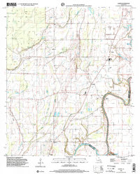
1998 Map of Lamar
USGS Topo · Published 2002About this map
Bayou Macon winds along the boundary between Franklin and Madison parishes, anchoring a landscape shaped by bottomland hydrology and agricultural development. Small settlements like Lamar, Bakers, and Longview serve as focal points for local history, while the presence of the Warsaw Ferry crossing reflects the historical reliance on river-based transit in this part of Louisiana. The terrain is a complex network of waterways, featuring Turkey Bayou, Johnson Bayou, and the swampy expanse of Bakers Brake.
Find a feature on this map
23 named features on this map. Tap any name to fly to it.
Don’t see what you’re looking for? This feature index may not catch every label — zoom into the map to look around manually.
Map Details
Editions of this 1998 Lamar Map
This is the sole edition of this map. No revisions or reprints were ever made.
Other maps of this area

1935 · Winnsboro
USGS Topo · 1:62,500

1935 · Baskinton
USGS Topo · 1:62,500

1935 · Waverly
USGS Topo · 1:62,500

1935 · Shackleford Lake
USGS Topo · 1:62,500

1955 · Jackson
USGS Topo · 1:250,000

1958 · Baskinton
USGS Topo · 1:62,500

1958 · Shackleford Lake
USGS Topo · 1:62,500

1958 · Winnsboro
USGS Topo · 1:62,500

1961 · Jackson
USGS Topo · 1:250,000

1961 · Waverly
USGS Topo · 1:62,500