
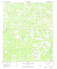
1968 Map of Lamartine
USGS Topo · Published 1969About this map
Willisville Oil Field dominates the northern landscape of this Columbia County survey, signaling the petroleum industry's impact on this rural terrain during the late 1960s. The settlement pattern is characterized by small, dispersed communities and crossroads anchored by local institutions like Kendrick Chapel and Pleasant Hill Sch. In the southern reaches, the community of Lamartine sits near the Shiloh Cem and Columbia Cem, preserving a record of family names and early local history. The land is drained by a network of waterways including Dorcheat Bayou, Cypress Creek, and Brushy Creek, which cross through the heavily wooded Stockton Bottom. This map captures the region just as modern infrastructure began to weave through established rural pockets like Bethel and Stockton, where fine red dashed lines indicate field and fence lines visible from 1965 aerial photography.
Find a feature on this map
31 named features on this map. Tap any name to fly to it.
Don’t see what you’re looking for? This feature index may not catch every label — zoom into the map to look around manually.
Map Details
Editions of this 1968 Lamartine Map
2 editions found
Other maps of this area

1901 · Gurdon
USGS Topo · 1:125,000

1953 · El Dorado
USGS Topo · 1:250,000

1957 · El Dorado
USGS Topo · 1:250,000

1958 · El Dorado
USGS Topo · 1:250,000

1960 · El Dorado
USGS Topo · 1:250,000

1968 · Buckner
USGS Topo · 1:24,000
1968 · Falcon
USGS Topo · 1:24,000

1968 · Waldo
USGS Topo · 1:24,000
1968 · Magnolia
USGS Topo · 1:24,000
1969 · Magnolia NW
USGS Topo · 1:24,000