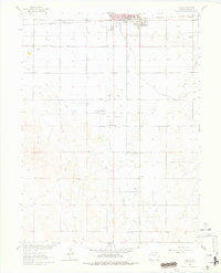
1963 Map of Lamb
USGS Topo · Published 1978About this map
Fort Morgan serves as the industrial and civic anchor of this Morgan County landscape during the early 1960s, where the expansion of the Fort Morgan Oil Field defines much of the surrounding terrain. The map documents an extensive network of Oil Wells, Gas Wells, and a central Gasoline Plant, illustrating the era's intensive energy extraction. This industrial activity is superimposed on a traditional agricultural foundation sustained by the Bijou Canal and Badger Creek.
Find a feature on this map
15 named features on this map. Tap any name to fly to it.
Don’t see what you’re looking for? This feature index may not catch every label — zoom into the map to look around manually.
Map Details
Editions of this 1963 Lamb Map
3 editions found
Other maps of this area

1951 · Weldona
USGS Topo · 1:24,000

1951 · Brush West
USGS Topo · 1:24,000

1951 · Fort Morgan
USGS Topo · 1:24,000

1954 · Sterling
USGS Topo · 1:250,000

1958 · Sterling
USGS Topo · 1:250,000

1963 · Lamb
USGS Topo · 1:24,000

1963 · Round Top
USGS Topo · 1:24,000

1963 · Vallery
USGS Topo · 1:24,000

1963 · Adena
USGS Topo · 1:24,000

1965 · Vallery SE
USGS Topo · 1:24,000