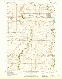
1967 Map of Lamberton
USGS Topo · Published 1969About this map
Lamberton and Revere anchor this agricultural landscape in the late 1960s, situated along the Chicago and North Western railroad line. The terrain is defined by the winding course of the Cottonwood River to the north and the intersecting drainages of Dutch Charley Creek and Highwater Creek to the south. A notable point of regional research is the Univ of Minn Experimental Sta, positioned near the river bluffs.
Find a feature on this map
21 named features on this map. Tap any name to fly to it.
Don’t see what you’re looking for? This feature index may not catch every label — zoom into the map to look around manually.
Map Details
Editions of this 1967 Lamberton Map
This is the sole edition of this map. No revisions or reprints were ever made.
Other maps of this area

1953 · New Ulm
USGS Topo · 1:250,000

1957 · New Ulm
USGS Topo · 1:250,000

1958 · New Ulm
USGS Topo · 1:250,000

1967 · New Ulm
USGS Topo · 1:250,000

1967 · Wanda
USGS Topo · 1:24,000

1967 · Sanborn
USGS Topo · 1:24,000

1967 · Wabasso SE
USGS Topo · 1:24,000

1967 · Walnut Grove
USGS Topo · 1:24,000

1967 · Storden
USGS Topo · 1:24,000

1967 · Jeffers
USGS Topo · 1:24,000