
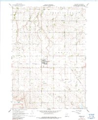
1967 Map of Jeffers
USGS Topo · Published 1968About this map
The Chicago and North Western railroad bisects the prairie landscape of Cottonwood County, anchoring the town of Jeffers. This late-1960s survey reveals a deeply rooted agricultural community where social life revolved around rural institutions like St Johns Ch and Red Rock Ch. The land is defined by its drainages, with the Watonwan River and Little Cottonwood River carving through the townships of Amboy, Storden, and Dale.
Find a feature on this map
22 named features on this map. Tap any name to fly to it.
Don’t see what you’re looking for? This feature index may not catch every label — zoom into the map to look around manually.
Map Details
Editions of this 1967 Jeffers Map
2 editions found
Other maps of this area

1953 · New Ulm
USGS Topo · 1:250,000

1954 · Fairmont
USGS Topo · 1:250,000

1957 · New Ulm
USGS Topo · 1:250,000

1958 · New Ulm
USGS Topo · 1:250,000

1958 · Fairmont
USGS Topo · 1:250,000

1967 · New Ulm
USGS Topo · 1:250,000

1967 · Sanborn
USGS Topo · 1:24,000

1967 · Sanborn SE
USGS Topo · 1:24,000

1967 · Sanborn NE
USGS Topo · 1:24,000

1967 · Storden
USGS Topo · 1:24,000