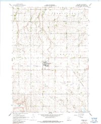
1967 Map of Jeffers
USGS Topo · Published 1988About this map
The agricultural landscape of Cottonwood County is defined here by the crossing of the Chicago and North Western railroad through the town of Jeffers. This 1967 field-checked survey reveals a rural society structured around township lines, including Highwater, Germantown, Storden, Amboy, and Amodale. Water management and drainage are central to the terrain, with the Little Cottonwood River and Watonwan River winding through the southern half of the quadrangle. Local infrastructure includes a Gaging Station on Dry Creek and a Landing Field situated among the farm sections. Genealogists and local historians can pinpoint community centers such as Red Rock Ch, St Johns Ch, and the local Townhall. Notable landmarks for family researchers include the Jeffers Cem and Red Rock Cem, providing specific locations for ancestral sites within this prairie environment.
Find a feature on this map
19 named features on this map. Tap any name to fly to it.
Don’t see what you’re looking for? This feature index may not catch every label — zoom into the map to look around manually.
Map Details
Editions of this 1967 Jeffers Map
2 editions found

Other maps of this area

1953 · New Ulm
USGS Topo · 1:250,000

1954 · Fairmont
USGS Topo · 1:250,000

1957 · New Ulm
USGS Topo · 1:250,000

1958 · New Ulm
USGS Topo · 1:250,000

1958 · Fairmont
USGS Topo · 1:250,000

1967 · New Ulm
USGS Topo · 1:250,000

1967 · Sanborn
USGS Topo · 1:24,000

1967 · Sanborn SE
USGS Topo · 1:24,000

1967 · Sanborn NE
USGS Topo · 1:24,000

1967 · Storden
USGS Topo · 1:24,000