
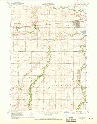
1967 Map of Storden
USGS Topo · Published 1968About this map
The agricultural landscape of Cottonwood County is anchored by the community of Storden, where the Chicago and North Western railroad provides a primary corridor for transit and trade. This 1960s survey documents a region defined by its prairie potholes and small glacial lakes, including Hurricane Lake and Augusta Lake. The Hurricane State Wildlife Management Area occupies the northern reaches, preserving the natural drainage patterns of Dutch Charley Creek and Highwater Creek.
Find a feature on this map
19 named features on this map. Tap any name to fly to it.
Don’t see what you’re looking for? This feature index may not catch every label — zoom into the map to look around manually.
Map Details
Editions of this 1967 Storden Map
This is the sole edition of this map. No revisions or reprints were ever made.
Other maps of this area

1953 · New Ulm
USGS Topo · 1:250,000

1954 · Fairmont
USGS Topo · 1:250,000

1957 · New Ulm
USGS Topo · 1:250,000

1958 · New Ulm
USGS Topo · 1:250,000

1958 · Fairmont
USGS Topo · 1:250,000

1967 · New Ulm
USGS Topo · 1:250,000

1967 · Sanborn
USGS Topo · 1:24,000

1967 · Walnut Grove
USGS Topo · 1:24,000

1967 · Jeffers
USGS Topo · 1:24,000
1967 · Lamberton
USGS Topo · 1:24,000