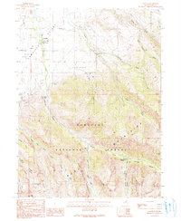
1990 Map of Lamoille
USGS Topo · Published 1990About this map
Lamoille marks the transition from the relatively level agricultural valley floor to the dramatic verticality of the Ruby Mountains Wilderness. This landscape is defined by its water system, where Lamoille Creek and its many tributaries, including Talbot Creek and Conrad Creek, descend from the high mountain basins. Local infrastructure and community markers are present in the form of a Cemetery, a Power House, and a F S Station, alongside evidence of resource extraction at a Borrow Pit and Quarry.
Find a feature on this map
41 named features on this map. Tap any name to fly to it.
Don’t see what you’re looking for? This feature index may not catch every label — zoom into the map to look around manually.
Map Details
Editions of this 1990 Lamoille Map
2 editions found
Other maps of this area

1935 · Halleck
USGS Topo · 1:125,000

1955 · Elko
USGS Topo · 1:250,000

1958 · Elko
USGS Topo · 1:250,000

1962 · Elko
USGS Topo · 1:250,000

1962 · Boyd Reservoir
USGS Topo · 1:24,000

1962 · Lee
USGS Topo · 1:62,500

1962 · Lamoille
USGS Topo · 1:62,500

1965 · Elko
USGS Topo · 1:250,000
1970 · Soldier Peak
USGS Topo · 1:24,000
1971 · Halleck SW
USGS Topo · 1:24,000