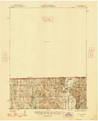
1947 Map of Lamoni
USGS Topo · Published 1947About this map
The Thompson River and East Fork Big Creek define the drainage of this rural borderland between Iowa and Missouri. In the mid-1940s, this landscape was dominated by small farming communities and a dense network of country schools, including Green Valley Sch, Lone Star Sch, and Cisco Sch. The settlement pattern follows the ridgelines, with local life centered around landmark institutions like Otterbein Ch and Riverview Ch.
Find a feature on this map
26 named features on this map. Tap any name to fly to it.
Don’t see what you’re looking for? This feature index may not catch every label — zoom into the map to look around manually.
Map Details
Editions of this 1947 Lamoni Map
2 editions found
Other maps of this area

1945 · Mount Ayr
USGS Topo · 1:62,500

1945 · Lamoni
USGS Topo · 1:62,500

1946 · Princeton
USGS Topo · 1:62,500

1947 · Lamoni
USGS Topo · 1:62,500

1947 · Blythedale
USGS Topo · 1:62,500

1947 · Mount Ayr
USGS Topo · 1:62,500

1948 · Bethany
USGS Topo · 1:62,500

1948 · Princeton
USGS Topo · 1:62,500

1954 · Centerville
USGS Topo · 1:250,000

1955 · Nebraska City
USGS Topo · 1:250,000