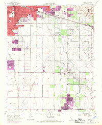
1954 Map of Lamont
USGS Topo · Published 1970About this map
The Bakersfield city boundary expands into a landscape defined by petroleum extraction and industrial agriculture at mid-century. While the northern edge of the map shows established urban blocks and the historic Union Cemetery, the territory to the south transitions into the dense infrastructure of the Mountain View Oil Field and Edison Oil Field. These oil fields are webbed with pipelines, sumps, and pumping stations, illustrating the era's intensive resource development.
Find a feature on this map
52 named features on this map. Tap any name to fly to it.
Don’t see what you’re looking for? This feature index may not catch every label — zoom into the map to look around manually.
Map Details
Editions of this 1954 Lamont Map
3 editions found
Other maps of this area

1906 · Bakersfield
USGS Topo · 1:62,500

1910 · Buena Vista Lake
USGS Topo · 1:125,000

1912 · Buena Vista Lake
USGS Topo · 1:125,000

1914 · Caliente
USGS Topo · 1:125,000

1929 · Fairfax School
USGS Topo · 1:31,680

1930 · Weed Patch
USGS Topo · 1:31,680

1930 · Arvin
USGS Topo · 1:31,680

1930 · Conner
USGS Topo · 1:31,680

1930 · Oildale
USGS Topo · 1:31,680

1931 · Edison
USGS Topo · 1:31,680