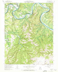
1956 Map of Lampe
USGS Topo · Published 1972About this map
James River loops through the northern half of this terrain, characterized by steep bluffs and prominent balds such as Naked Joe Bald and Big Joe Bald. The landscape is dominated by the Mark Twain National Forest, where high ridges like Oak Ridge and Bread Tray Mountain rise above a complex network of hollows, including Blowing Springs Hollow and Wildcat Hollow. The settlement of Lampe serves as a local hub near a Lookout Tower, reflecting a period when fire observation and forest management were central to the region.
Find a feature on this map
56 named features on this map. Tap any name to fly to it.
Don’t see what you’re looking for? This feature index may not catch every label — zoom into the map to look around manually.
Map Details
Editions of this 1956 Lampe Map
3 editions found

Other maps of this area

1900 · Eureka Springs
USGS Topo · 1:125,000

1901 · Eureka Springs
USGS Topo · 1:125,000

1904 · Harrison
USGS Topo · 1:125,000

1905 · Harrison
USGS Topo · 1:125,000

1907 · Forsyth
USGS Topo · 1:125,000

1927 · Shell Knob
USGS Topo · 1:62,500

1945 · Harrison
USGS Topo · 1:250,000

1949 · Harrison
USGS Topo · 1:250,000

1950 · Shell Knob
USGS Topo · 1:62,500

1950 · Garber
USGS Topo · 1:24,000