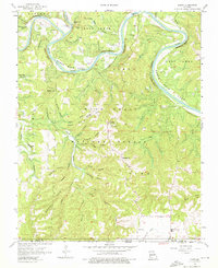
1956 Map of Lampe
USGS Topo · Published 1976About this map
The James River and its transition into Table Rock Lake dominate this Ozark landscape, illustrating the area just as the reservoir began to transform the local geography. The winding river course is flanked by significant local landmarks and family-named bluffs like Philibert Bluff and Logslide Bluff. Centered on the settlement of Lampe, the map captures a rural network of ridges and hollows within the Mark Twain National Forest. The presence of Highview Ch and numerous family burial grounds, including Philibert Cem and Yates Cem, provide a valuable record of early settlement patterns and genealogy. Distinctive terrain features such as Bread Tray Mountain and the curiously named Naked Joe Bald stand out among the dense topography of the region, while a Lookout Tower near Lampe marks a key point of forest management in the mid-1950s.
Find a feature on this map
67 named features on this map. Tap any name to fly to it.
Don’t see what you’re looking for? This feature index may not catch every label — zoom into the map to look around manually.
Map Details
Editions of this 1956 Lampe Map
3 editions found

Other maps of this area

1900 · Eureka Springs
USGS Topo · 1:125,000

1901 · Eureka Springs
USGS Topo · 1:125,000

1904 · Harrison
USGS Topo · 1:125,000

1905 · Harrison
USGS Topo · 1:125,000

1907 · Forsyth
USGS Topo · 1:125,000

1927 · Shell Knob
USGS Topo · 1:62,500

1945 · Harrison
USGS Topo · 1:250,000

1949 · Harrison
USGS Topo · 1:250,000

1950 · Shell Knob
USGS Topo · 1:62,500

1950 · Garber
USGS Topo · 1:24,000