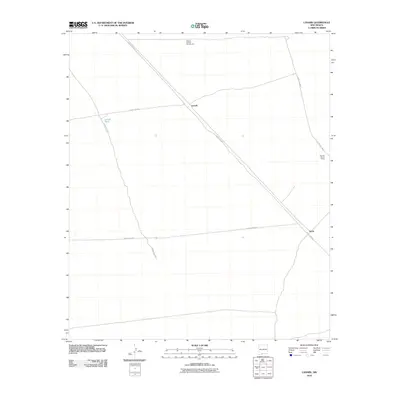
2010 Map of Lanark
USGS Topo · Published 2010About this map
Lanark sits at the intersection of a sparse road network in this high-desert stretch of Doña Ana County. The landscape is defined by long, straight thoroughfares including County Rd-A017, which cuts diagonally across the quadrangle, and County Rd A011. Industrial and agricultural activity is concentrated in a few specific locations, most notably at the Weaver Federal Number One mine and the Hall and Primm Ranch. Water management in this arid environment is highlighted by the presence of Lanark Tank. The small settlement of Vevay occupies the southeastern corner of the map, illustrating the isolated nature of human habitation in the region during the early 21st century. The map provides a clear picture of how resource extraction and ranching infrastructures are distributed across this open terrain.
Find a feature on this map
10 named features on this map. Tap any name to fly to it.
Don’t see what you’re looking for? This feature index may not catch every label — zoom into the map to look around manually.
Map Details
Editions of this 2010 Lanark Map
This is the sole edition of this map. No revisions or reprints were ever made.
Other maps of this area

1891 · Las Cruces
USGS Topo · 1:125,000

1893 · Las Cruces
USGS Topo · 1:125,000

1917 · Canutillo
USGS Topo · 1:62,500

1917 · Noria
USGS Topo · 1:62,500

1918 · Noria
USGS Topo · 1:62,500

1919 · Canutillo
USGS Topo · 1:62,500

1943 · La Mesa
USGS Topo · 1:62,500

1943 · Afton
USGS Topo · 1:62,500

1953 · El Paso
USGS Topo · 1:250,000
1955 · Strauss
USGS Topo · 1:24,000