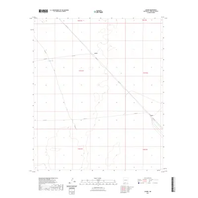
2023 Map of Lanark
USGS Topo · Published 2023About this map
Lanark sits as a primary point of interest in this high-desert region of the Mesilla Valley, where the vast landscape is defined by the rigid grid of the Public Land Survey System. The map documents a sparse but deliberate network of county roads, including Co Rd A-12 and Co Rd A011, which cut diagonally across the township lines of t27s r1e and t27s r2e. This area's reliance on water management is evident at the Lanark Tank, a critical resource in the arid terrain of southern New Mexico. To the southeast, the settlement of Vevay marks another localized hub along the thoroughfares like Co Rd A-14. The topography is characterized by subtle elevation changes and depressions, illustrating the natural drainage patterns that dictate the placement of local infrastructure and these scattered outposts.
Find a feature on this map
17 named features on this map. Tap any name to fly to it.
Don’t see what you’re looking for? This feature index may not catch every label — zoom into the map to look around manually.
Map Details
Editions of this 2023 Lanark Map
This is the sole edition of this map. No revisions or reprints were ever made.
Other maps of this area

1891 · Las Cruces
USGS Topo · 1:125,000

1893 · Las Cruces
USGS Topo · 1:125,000

1917 · Canutillo
USGS Topo · 1:62,500

1917 · Noria
USGS Topo · 1:62,500

1918 · Noria
USGS Topo · 1:62,500

1919 · Canutillo
USGS Topo · 1:62,500

1943 · La Mesa
USGS Topo · 1:62,500

1943 · Afton
USGS Topo · 1:62,500

1953 · El Paso
USGS Topo · 1:250,000
1955 · Strauss
USGS Topo · 1:24,000