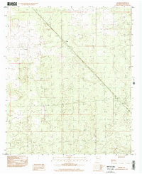
1996 Map of Lanark
USGS Topo · Published 2002About this map
Lanark serves as a lonely outpost in the high desert of Doña Ana County, defined by its relationship with the Southern Pacific railroad. The steel rails of the mainline cut a long, straight diagonal across the arid basin, reflecting the logistical importance of this corridor for transcontinental transit through southern New Mexico. As a provisional survey based on earlier manuscript drawings and 1996 imagery, the map documents the sparse industrial infrastructure required for rail operations in a water-scarce environment. The presence of the Lanark Tank north of the settlement indicates the essential need for steam-era or maintenance watering stops that once sustained engines through this territory. Beyond these few signs of human engineering, the landscape is primarily characterized by subtle topographic contours and desert scrub.
Find a feature on this map
3 named features on this map. Tap any name to fly to it.
Don’t see what you’re looking for? This feature index may not catch every label — zoom into the map to look around manually.
Map Details
Editions of this 1996 Lanark Map
This is the sole edition of this map. No revisions or reprints were ever made.
Other maps of this area

1891 · Las Cruces
USGS Topo · 1:125,000

1893 · Las Cruces
USGS Topo · 1:125,000

1917 · Canutillo
USGS Topo · 1:62,500

1917 · Noria
USGS Topo · 1:62,500

1918 · Noria
USGS Topo · 1:62,500

1919 · Canutillo
USGS Topo · 1:62,500

1943 · La Mesa
USGS Topo · 1:62,500

1943 · Afton
USGS Topo · 1:62,500

1953 · El Paso
USGS Topo · 1:250,000
1955 · Strauss
USGS Topo · 1:24,000