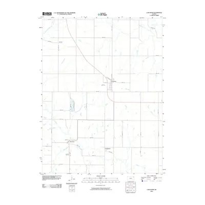
2009 Map of Lancaster
USGS Topo · Published 2009About this map
Stranger Creek and its many tributaries, including the North Fork Stranger Creek and Little Stranger Creek, define the agricultural layout of this Atchison County landscape. The settlement of Lancaster serves as a central hub, situated where the grid of rural roads meets the diagonal path of the highway. Further south, the smaller communities of Monrovia and Farmington anchor the local farming economy, connected by a network of numbered rural routes such as 266th Rd and 262nd Rd. Local history is preserved at the Old Huron Cemetery in the northwest and the Monrovia Cemetery near the southern border, providing clear landmarks for genealogical research. The map illustrates a classic Midwestern township pattern, where the natural winding courses of Camp Creek and Independence Creek break the rigid geometry of the section lines.
Find a feature on this map
41 named features on this map. Tap any name to fly to it.
Don’t see what you’re looking for? This feature index may not catch every label — zoom into the map to look around manually.
Map Details
Editions of this 2009 Lancaster Map
This is the sole edition of this map. No revisions or reprints were ever made.
Other maps of this area

1885 · Atchison
USGS Topo · 1:125,000

1886 · Oskaloosa
USGS Topo · 1:125,000

1888 · Oskaloosa
USGS Topo · 1:125,000

1888 · Atchison
USGS Topo · 1:125,000

1893 · Atchison
USGS Topo · 1:125,000

1894 · Oskaloosa
USGS Topo · 1:125,000

1926 · Atchison
USGS Topo · 1:62,500

1950 · Kansas City
USGS Topo · 1:250,000

1954 · Kansas City
USGS Topo · 1:250,000

1956 · Kansas City
USGS Topo · 1:250,000