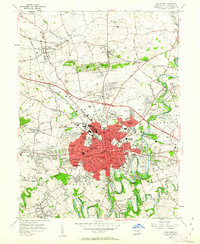
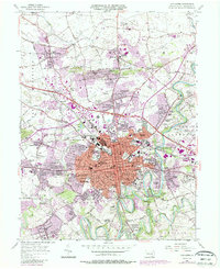
1956 Map of Lancaster
USGS Topo · Published 1962About this map
The dense grid of Lancaster anchors this mid-century landscape, radiating outward from the central Courthouse and City Hall into sprawling residential developments like Rossmere and Grandview Heights. The city's educational and institutional backbone is clearly visible, featuring Franklin and Marshall College and the State Teachers College further south in Millersville. The transition from urban density to rural farmland is marked by family-named crossroads and small clusters like Zooks Corner, Florys Mill, and Landis Valley, where the Conestoga River and its many tributaries, including Little Conestoga Creek and Landis Valley Run, carve through the rolling hills.
Find a feature on this map
126 named features on this map. Tap any name to fly to it.
Don’t see what you’re looking for? This feature index may not catch every label — zoom into the map to look around manually.
Map Details
Editions of this 1956 Lancaster Map
5 editions found
Other maps of this area

1902 · Lancaster
USGS Topo · 1:62,500

1904 · Lancaster
USGS Topo · 1:62,500

1906 · New Holland
USGS Topo · 1:62,500

1908 · New Holland
USGS Topo · 1:62,500

1912 · Quarryville
USGS Topo · 1:62,500

1912 · Mc Calls Ferry
USGS Topo · 1:62,500

1941 · New Holland
USGS Topo · 1:62,500

1943 · Lancaster
USGS Topo · 1:62,500

1943 · Quarryville
USGS Topo · 1:62,500

1943 · Mc Calls Ferry
USGS Topo · 1:62,500
Featured Places
- Lancaster, PA
- West Lampeter Township, PA
- Willow Street, West Lampeter Township
- Millersville, PA
- East Petersburg, PA