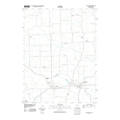
2010 Map of Lancaster
USGS Topo · Published 2010About this map
Lancaster and Glenwood anchor this northern Missouri landscape, where the agricultural grid is etched with historical family names and community landmarks. The area is defined by the winding course of the South Fork North Fabius River and several managed water bodies like Ursel Gingerich Lake and Lancaster City Lake. For genealogists, the map is particularly detailed, locating numerous burial grounds including the Independent Order of Odd Fellows Cemetery, Washington Cemetery, and Coatsville Cemetery. Small settlements like Glenwood Junction and Anderson Corner reflect the rural intersection points that once facilitated local trade. The road network, with names like All Shire School Rd and Red School Rd, hints at the locations of former country schoolhouses that served the surrounding farmsteads.
Find a feature on this map
52 named features on this map. Tap any name to fly to it.
Don’t see what you’re looking for? This feature index may not catch every label — zoom into the map to look around manually.
Map Details
Editions of this 2010 Lancaster Map
This is the sole edition of this map. No revisions or reprints were ever made.
Other maps of this area

1903 · Edina
USGS Topo · 1:125,000

1911 · Queen City
USGS Topo · 1:62,500

1913 · Queen City
USGS Topo · 1:62,500

1954 · Centerville
USGS Topo · 1:250,000

1957 · Centerville
USGS Topo · 1:250,000

1958 · Centerville
USGS Topo · 1:250,000

1965 · Downing NW
USGS Topo · 1:24,000
1974 · Queen City NE
USGS Topo · 1:24,000
1974 · Queen City NW
USGS Topo · 1:24,000
1979 · Queen City
USGS Topo · 1:24,000