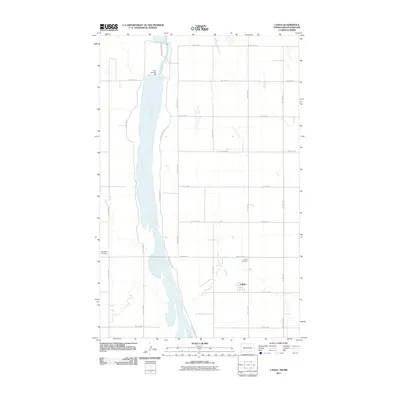
2011 Map of Landa
USGS Topo · Published 2011About this map
The Souris River dominates this north-central North Dakota landscape, flowing through a strictly gridded prairie environment near the Canadian border. The small settlement of Landa serves as the primary focal point of the area, located just east of the river valley. The map documents the local hydrology managed by Dam Number 357, which regulates the river's flow through the wide, flat basin. This 2011 survey reveals a landscape largely defined by section-line roads such as County Rd-27A and County Rd-33, with the specialized Refuge Private Rd tracing the river's eastern edge. Family historians and local researchers will find the Landa Cemetery and Westhope Cemetery clearly marked, providing essential landmarks for tracing the heritage of this rural Bottineau County community.
Find a feature on this map
24 named features on this map. Tap any name to fly to it.
Don’t see what you’re looking for? This feature index may not catch every label — zoom into the map to look around manually.
Map Details
Editions of this 2011 Landa Map
This is the sole edition of this map. No revisions or reprints were ever made.
Other maps of this area

1949 · Landa
USGS Topo · 1:24,000

1949 · Landa SW
USGS Topo · 1:24,000

1950 · Landa
USGS Topo · 1:24,000

1950 · Landa SW
USGS Topo · 1:24,000

1951 · Westhope SE
USGS Topo · 1:24,000
1951 · Westhope
USGS Topo · 1:24,000

1954 · Landa SE
USGS Topo · 1:24,000

1954 · Roth
USGS Topo · 1:24,000

1954 · Minot
USGS Topo · 1:250,000

1958 · Minot
USGS Topo · 1:250,000