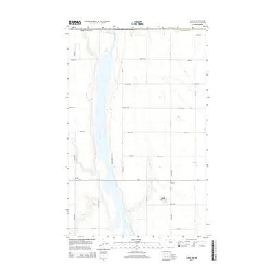
2014 Map of Landa
USGS Topo · Published 2014About this map
Landa and the surrounding plains of Bottineau County are defined by the meandering path of the Souris River, which carves through the central portion of this 2014 survey. The landscape is a structured grid of rural section roads, including 108th St NW and Cr-27a, interspersed with small prairie potholes and wetlands typical of the North Dakota borderlands. In the upper reaches of the river, the Unit 357 Reservoir provides water management within the valley, while the Refuge Private Rd tracks along the western bank.
Find a feature on this map
28 named features on this map. Tap any name to fly to it.
Don’t see what you’re looking for? This feature index may not catch every label — zoom into the map to look around manually.
Map Details
Editions of this 2014 Landa Map
This is the sole edition of this map. No revisions or reprints were ever made.
Other maps of this area

1949 · Landa
USGS Topo · 1:24,000

1949 · Landa SW
USGS Topo · 1:24,000

1950 · Landa
USGS Topo · 1:24,000

1950 · Landa SW
USGS Topo · 1:24,000

1951 · Westhope SE
USGS Topo · 1:24,000
1951 · Westhope
USGS Topo · 1:24,000

1954 · Landa SE
USGS Topo · 1:24,000

1954 · Roth
USGS Topo · 1:24,000

1954 · Minot
USGS Topo · 1:250,000

1958 · Minot
USGS Topo · 1:250,000