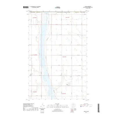
2017 Map of Landa
USGS Topo · Published 2017About this map
The Souris River meanders through the heart of this Bottineau County landscape, its broad floodplain and associated wetlands defining the North Dakota prairie. Just south of the United States and Canada border, the small settlement of Landa serves as a focal point for the surrounding agricultural community. The landscape is organized by a precise grid of section lines and rural routes, such as 103rd St NW and 10th Ave NW, which connect the scattered farmsteads of the region. Local history and genealogy are anchored by the Landa Cem near the townsite and Westhope Cem to the west. This 2017 survey reveals the persistent importance of the river corridor, where Refuge Private Rd traces the edge of the valley, highlighting the relationship between the prairie uplands and the riparian basin.
Find a feature on this map
31 named features on this map. Tap any name to fly to it.
Don’t see what you’re looking for? This feature index may not catch every label — zoom into the map to look around manually.
Map Details
Editions of this 2017 Landa Map
This is the sole edition of this map. No revisions or reprints were ever made.
Other maps of this area

1949 · Landa
USGS Topo · 1:24,000

1949 · Landa SW
USGS Topo · 1:24,000

1950 · Landa
USGS Topo · 1:24,000

1950 · Landa SW
USGS Topo · 1:24,000

1951 · Westhope SE
USGS Topo · 1:24,000
1951 · Westhope
USGS Topo · 1:24,000

1954 · Landa SE
USGS Topo · 1:24,000

1954 · Roth
USGS Topo · 1:24,000

1954 · Minot
USGS Topo · 1:250,000

1958 · Minot
USGS Topo · 1:250,000