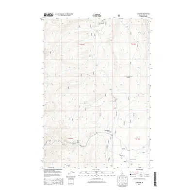
2013 Map of Landmark
USGS Topo · Published 2013About this map
Landmark serves as a central point in this high-elevation region of the Boise National Forest, situated at the intersection of critical forest access routes. The settlement's infrastructure includes the Landmark USFS Airport, supporting backcountry aviation and fire management. The landscape is defined by the drainages of Johnson Cr, Trout Cr, and Park Cr, which carve through the terrain surrounding Buck Mtn. Recreational development is evident in the cluster of designated sites like Summit Lake Campground, Pen Basin Campground, and Trout Creek Campground. Further south, Warm Lake and the distinctive geological formation at Landmark Rock provide clear navigational waypoints for those traveling along Warm Lake Rd and Johnson Creek Rd.
Find a feature on this map
35 named features on this map. Tap any name to fly to it.
Don’t see what you’re looking for? This feature index may not catch every label — zoom into the map to look around manually.
Map Details
Editions of this 2013 Landmark Map
This is the sole edition of this map. No revisions or reprints were ever made.
Other maps of this area

1937 · Yellow Pine
USGS Topo · 1:48,000

1943 · Yellow Pine
USGS Topo · 1:62,500

1954 · Warm Lake
USGS Topo · 1:62,500

1957 · Challis
USGS Topo · 1:250,000

1960 · Challis
USGS Topo · 1:250,000

1961 · Chinook Mtn
USGS Topo · 1:62,500

1963 · Challis
USGS Topo · 1:250,000
1973 · Chilcoot Peak
USGS Topo · 1:24,000

1973 · White Rock Peak
USGS Topo · 1:24,000
1973 · Log Mountain
USGS Topo · 1:24,000