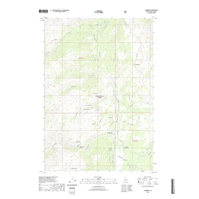
2020 Map of Landmark
USGS Topo · Published 2020About this map
Landmark serves as a central point of reference in this remote stretch of the Boise National Forest, situated near the high-altitude Landmark USFS Airport. The topography is defined by the significant elevations of Buck Mtn and the broad expanse of Lunch Creek Flat, where various spurs of the Stanley-Warm Lake road network converge. The landscape is heavily dissected by drainages such as Johnson Cr and Burnt Log Cr, which guide the path of forest access routes like Burnt Log. Water features are prominent throughout the terrain, from the secluded Knox Lake and Summit Lake to the headwaters of Warm Lake Cr. This 2020 representation of Valley County illustrates the complex forest management infrastructure, including the distinct Fulton Loop and the prominent geological formation of Landmark Rock in the southern reaches of Pen Basin.
Find a feature on this map
83 named features on this map. Tap any name to fly to it.
Don’t see what you’re looking for? This feature index may not catch every label — zoom into the map to look around manually.
Map Details
Editions of this 2020 Landmark Map
This is the sole edition of this map. No revisions or reprints were ever made.
Other maps of this area

1937 · Yellow Pine
USGS Topo · 1:48,000

1943 · Yellow Pine
USGS Topo · 1:62,500

1954 · Warm Lake
USGS Topo · 1:62,500

1957 · Challis
USGS Topo · 1:250,000

1960 · Challis
USGS Topo · 1:250,000

1961 · Chinook Mtn
USGS Topo · 1:62,500

1963 · Challis
USGS Topo · 1:250,000
1973 · Chilcoot Peak
USGS Topo · 1:24,000

1973 · White Rock Peak
USGS Topo · 1:24,000
1973 · Log Mountain
USGS Topo · 1:24,000