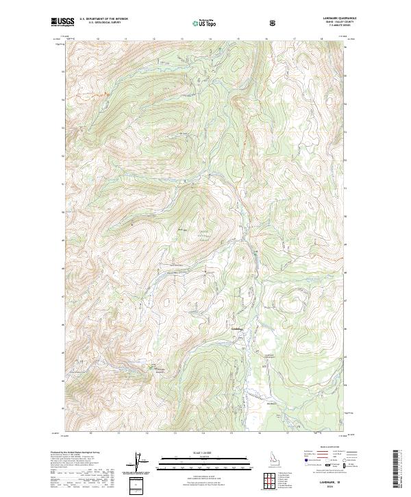
2024 Map of Landmark
USGS Topo · Published 2024About this map
Landmark serves as a central hub for transportation and forest management within the Boise National Forest in this mountain survey. The area is defined by a series of significant drainage basins and peaks, including the high-elevation Buck Mountain and the broad alluvial space of Pen Basin. The Landmark USFS Airport highlights the region's importance as a base for aerial operations in the backcountry, while the crossing at Warm Lake Summit marks a primary transit point for those navigating the watershed between Warm Lake Creek and the headwaters of major local streams. Notable historical corridors like the Stanley-Warm Lake road and the Burnt Log Trl provide evidence of the established routes used for resource access and travel through the Valley County wilderness.
Find a feature on this map
33 named features on this map. Tap any name to fly to it.
Don’t see what you’re looking for? This feature index may not catch every label — zoom into the map to look around manually.
Map Details
Editions of this 2024 Landmark Map
This is the sole edition of this map. No revisions or reprints were ever made.
Other maps of this area

1937 · Yellow Pine
USGS Topo · 1:48,000

1943 · Yellow Pine
USGS Topo · 1:62,500

1954 · Warm Lake
USGS Topo · 1:62,500

1957 · Challis
USGS Topo · 1:250,000

1960 · Challis
USGS Topo · 1:250,000

1961 · Chinook Mtn
USGS Topo · 1:62,500

1963 · Challis
USGS Topo · 1:250,000
1973 · Chilcoot Peak
USGS Topo · 1:24,000

1973 · White Rock Peak
USGS Topo · 1:24,000
1973 · Log Mountain
USGS Topo · 1:24,000