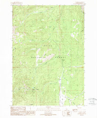
1988 Map of Landmark
USGS Topo · Published 1988About this map
Landmark serves as a central point of reference in this mountain landscape within the Boise National Forest. The 1988 provisional survey details a remote backcountry network of campgrounds and USFS facilities, anchored by the Landmark USFS Airport and nearby Landmark Rock. The drainage pattern is dominated by Johnson Creek and its many tributaries, including Trout Creek, Bobcat Creek, and Fulton Creek. High-elevation features like Warm Lake Summit and Buck Mountain overlook a series of small, isolated waters such as Knox Lake and Summit Lake. This map captures the area as it was managed for recreation and forestry in the 1980s, noting developed sites like Trout Creek Campground, Buck Mountain Campground, and Summit Lake Campground. The presence of 4WD tracks and a prominent trans line indicates the limited but essential infrastructure crossing these peaks and valleys.
Find a feature on this map
33 named features on this map. Tap any name to fly to it.
Don’t see what you’re looking for? This feature index may not catch every label — zoom into the map to look around manually.
Map Details
Editions of this 1988 Landmark Map
This is the sole edition of this map. No revisions or reprints were ever made.
Other maps of this area

1937 · Yellow Pine
USGS Topo · 1:48,000

1943 · Yellow Pine
USGS Topo · 1:62,500

1954 · Warm Lake
USGS Topo · 1:62,500

1957 · Challis
USGS Topo · 1:250,000

1960 · Challis
USGS Topo · 1:250,000

1961 · Chinook Mtn
USGS Topo · 1:62,500

1963 · Challis
USGS Topo · 1:250,000
1973 · Chilcoot Peak
USGS Topo · 1:24,000

1973 · White Rock Peak
USGS Topo · 1:24,000
1973 · Log Mountain
USGS Topo · 1:24,000