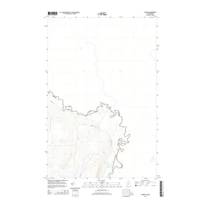
2014 Map of Landry
USGS Topo · Published 2014About this map
The settlement of Landry occupies a thin peninsula of high ground in the northern reaches of Aroostook Co, defined by the sharp, winding meanders of the international border. This 2014 survey documents the rugged geography where the United States and Canada are separated by river systems and dense forest. The terrain is marked by steep elevation changes, particularly around Kelly Rapids and the valley of Jones Brook, which drains into the boundary waters. Access to this remote border region is primarily served by Landry Rd, tracing the ridgelines above the river bends. The map illustrates the sparsely populated character of the north woods in the early 21st century, where human activity is limited to a few arterial roads and isolated settlements near the frontier.
Find a feature on this map
8 named features on this map. Tap any name to fly to it.
Don’t see what you’re looking for? This feature index may not catch every label — zoom into the map to look around manually.
Map Details
Editions of this 2014 Landry Map
This is the sole edition of this map. No revisions or reprints were ever made.
Other maps of this area

1955 · Beau Lake
USGS Topo · 1:62,500

1962 · Edmundston
USGS Topo · 1:250,000
1986 · Landry
USGS Topo · 1:24,000

1987 · Beau Lake
USGS Topo · 1:24,000

1987 · Hafey Pond
USGS Topo · 1:24,000
1987 · Estcourt
USGS Topo · 1:24,000
1993 · Allagash
USGS Topo · 1:100,000
1994 · Madawaska
USGS Topo · 1:100,000
2011 · Hafey Pond
USGS Topo · 1:24,000
2011 · Landry
USGS Topo · 1:24,000