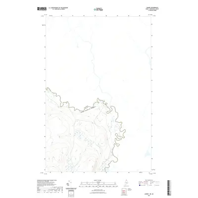
2021 Map of Landry
USGS Topo · Published 2021About this map
The Saint Francis River serves as the prominent natural boundary between the United States and Canada in this remote northern Maine landscape. The river's path is marked by features like the Kelly Rapids, reflecting a waterway that remains largely untouched by heavy development. In the southern portion of the sheet, Beau Lake straddles the international border, fed by the winding course of Jones Brook. This topographic study reveals a terrain of significant elevation changes and dense wetlands, characteristic of the North Maine Woods. The absence of roads or established settlements emphasizes the area's role as a rugged wilderness corridor where the topography dictates the flow of water across the international line.
Find a feature on this map
5 named features on this map. Tap any name to fly to it.
Don’t see what you’re looking for? This feature index may not catch every label — zoom into the map to look around manually.
Map Details
Editions of this 2021 Landry Map
This is the sole edition of this map. No revisions or reprints were ever made.
Other maps of this area

1955 · Beau Lake
USGS Topo · 1:62,500

1962 · Edmundston
USGS Topo · 1:250,000
1986 · Landry
USGS Topo · 1:24,000

1987 · Beau Lake
USGS Topo · 1:24,000

1987 · Hafey Pond
USGS Topo · 1:24,000
1987 · Estcourt
USGS Topo · 1:24,000
1993 · Allagash
USGS Topo · 1:100,000
1994 · Madawaska
USGS Topo · 1:100,000
2011 · Hafey Pond
USGS Topo · 1:24,000
2011 · Landry
USGS Topo · 1:24,000