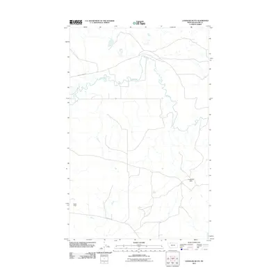
2011 Map of Landslide Butte
USGS Topo · Published 2011About this map
The Milk River meanders across this northern Montana landscape, carving a serpentine path through the terrain of Glacier County. The waterway dominates the northern half of the sheet, surrounded by a network of drainage channels that define the local topography. To the south, prominent natural landmarks such as Landslide Butte and Eagle Point rise above the surrounding plains, serving as significant navigational markers in this open country. The human imprint on the land is represented by established routes such as William Johnson Rd and Chalk Butte Rd, which provide access across the river valley and toward the high points. This 2011 survey captures the area's transition between riparian corridors and the elevated buttes, illustrating the sparse but deliberate infrastructure required to navigate this portion of the High Plains.
Find a feature on this map
5 named features on this map. Tap any name to fly to it.
Don’t see what you’re looking for? This feature index may not catch every label — zoom into the map to look around manually.
Map Details
Editions of this 2011 Landslide Butte Map
This is the sole edition of this map. No revisions or reprints were ever made.
Other maps of this area

1911 · Blackfoot
USGS Topo · 1:125,000

1960 · Cut Bank
USGS Topo · 1:250,000

1963 · Cut Bank
USGS Topo · 1:250,000

1964 · Cut Bank
USGS Topo · 1:250,000

1968 · Buffalo Lake
USGS Topo · 1:24,000
1968 · Love Rock
USGS Topo · 1:24,000

1968 · Rocky Buttes
USGS Topo · 1:24,000
1968 · Del Bonita
USGS Topo · 1:24,000

1968 · Landslide Butte
USGS Topo · 1:24,000
1968 · Rimrock Ranch
USGS Topo · 1:24,000