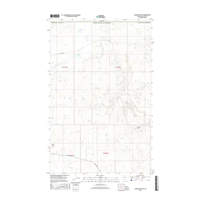
2017 Map of Landslide Butte
USGS Topo · Published 2017About this map
The Milk River meanders through the northern reaches of this borderland, where the high plains of Montana meet the international boundary with Canada. This landscape is defined by its dramatic elevation changes, notably at Landslide Butte and Eagle Point, which rise above the surrounding drainage basins. The area reflects the sparse, expansive nature of Glacier County ranching and rural life, connected by solitary routes like William Johnson Rd and Chalk Butte Rd. The map illustrates the structured division of the land into townships such as t37n r9w and t36n r8w, a legacy of the Public Land Survey System that continues to shape the geographic organization of this remote northern territory.
Find a feature on this map
12 named features on this map. Tap any name to fly to it.
Don’t see what you’re looking for? This feature index may not catch every label — zoom into the map to look around manually.
Map Details
Editions of this 2017 Landslide Butte Map
This is the sole edition of this map. No revisions or reprints were ever made.
Other maps of this area

1911 · Blackfoot
USGS Topo · 1:125,000

1960 · Cut Bank
USGS Topo · 1:250,000

1963 · Cut Bank
USGS Topo · 1:250,000

1964 · Cut Bank
USGS Topo · 1:250,000

1968 · Buffalo Lake
USGS Topo · 1:24,000
1968 · Love Rock
USGS Topo · 1:24,000

1968 · Rocky Buttes
USGS Topo · 1:24,000
1968 · Del Bonita
USGS Topo · 1:24,000

1968 · Landslide Butte
USGS Topo · 1:24,000
1968 · Rimrock Ranch
USGS Topo · 1:24,000