1966 Map of Lane
USGS Topo · Published 1983About this map
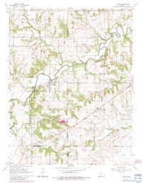
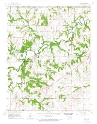
Pottawatomie Creek meanders deeply across this landscape, serving as a primary geographical anchor for the town of Lane. The settlement is situated near a sharp bend in the waterway, where the Missouri Pacific railroad line runs parallel to the bank. This 1966 survey, updated with 1980s data, illustrates a rural transition where multiple township boundaries converge, including Cutler, Osawatomie, and Walker.
Find a feature on this map
30 named features on this map. Tap any name to fly to it.
Don’t see what you’re looking for? This feature index may not catch every label — zoom into the map to look around manually.
Map Details
Editions of this 1966 Lane Map
2 editions found
Other maps of this area

1885 · Garnett
USGS Topo · 1:125,000

1885 · Lawrence
USGS Topo · 1:125,000

1887 · Olathe
USGS Topo · 1:125,000

1887 · Mound City
USGS Topo · 1:125,000

1889 · Lawrence
USGS Topo · 1:125,000

1893 · Mound City
USGS Topo · 1:125,000

1893 · Olathe
USGS Topo · 1:125,000

1894 · Garnett
USGS Topo · 1:125,000

1947 · Lawrence
USGS Topo · 1:250,000

1950 · Lawrence
USGS Topo · 1:250,000