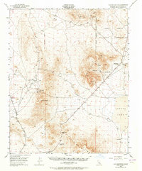
1948 Map of Lane Mountain
USGS Topo · Published 1964About this map
Lane Mountain rises above a rugged desert landscape where mining and military operations defined the mid-century geography of this portion of San Bernardino County. The northern reaches are dominated by the Camp Irwin Military Reservation, while the high ground of the Paradise Range and Calico Mountains is peppered with hard-rock mining claims. Notable extractions are recorded at the Gold Divide Mine, Montana Mine, and the Olympus Mine. For those researching local history or the movement of early travelers, the location of essential water sources like Williams Well, Paradise Spr, and Coyote Well reveal the vital waypoints across the arid terrain. The presence of Jackhammer Gap and Pickhandle Pass provides insight into the natural corridors used for transit between the high peaks and the floor of Coyote Lake.
Find a feature on this map
24 named features on this map. Tap any name to fly to it.
Don’t see what you’re looking for? This feature index may not catch every label — zoom into the map to look around manually.
Map Details
Editions of this 1948 Lane Mountain Map
3 editions found
Other maps of this area

1915 · Searles Lake
USGS Topo · 1:250,000

1932 · Barstow
USGS Topo · 1:125,000

1933 · Avawatz Mountains
USGS Topo · 1:250,000

1934 · Barstow
USGS Topo · 1:125,000

1947 · Trona
USGS Topo · 1:250,000

1948 · Trona
USGS Topo · 1:250,000

1948 · Alvord Mountain
USGS Topo · 1:62,500

1948 · Lane Mountain
USGS Topo · 1:62,500

1948 · Goldstone Lake
USGS Topo · 1:62,500

1948 · Tiefort Mountains
USGS Topo · 1:62,500