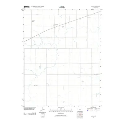
2009 Map of Langdon
USGS Topo · Published 2009About this map
Langdon and Lerado anchor this rural section of Reno County, where the agricultural grid is defined by a network of long section-line roads. The landscape is bisected by State Hwy 61, which cuts diagonally across the northern portion of the map, passing through the town of Langdon. To the west of the town site, the F M Stout Memorial Airport provides a modern navigational landmark amidst the sprawling fields.
Find a feature on this map
23 named features on this map. Tap any name to fly to it.
Don’t see what you’re looking for? This feature index may not catch every label — zoom into the map to look around manually.
Map Details
Editions of this 2009 Langdon Map
This is the sole edition of this map. No revisions or reprints were ever made.
Other maps of this area

1892 · Kingman
USGS Topo · 1:125,000

1894 · Kingman
USGS Topo · 1:125,000

1955 · Pratt
USGS Topo · 1:250,000

1959 · Pratt
USGS Topo · 1:250,000

1966 · Cunningham
USGS Topo · 1:24,000

1967 · Kingman NW
USGS Topo · 1:24,000

1967 · Penalosa
USGS Topo · 1:24,000
1971 · Turon
USGS Topo · 1:24,000
1971 · Sylvia
USGS Topo · 1:24,000
1971 · Pretty Prairie SW
USGS Topo · 1:24,000