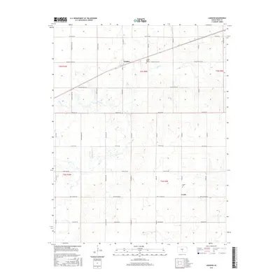
2015 Map of Langdon
USGS Topo · Published 2015About this map
The community of Langdon and its adjacent Langdon Maple Hill Cem anchor the northern landscape of this Reno County study. Tracing the regional topography reveals a network of watercourses including Wolf Cr, Silver Cr, and Goose Cr which flow across the prairie. The settlement of Lerado lies to the south, marked by the Lerado Cem and served by a grid of named rural roads like Pretty Prairie Rd and Silver Lake Rd. This 2015 data reflects a long-established agricultural grid, where townships like t25s r9w are bisected by through-routes such as Fountain Green Rd and Pleasant Valley Rd. The map illustrates the persistent structure of Kansas section lines and the small rural centers that historically supported the surrounding farming community.
Find a feature on this map
29 named features on this map. Tap any name to fly to it.
Don’t see what you’re looking for? This feature index may not catch every label — zoom into the map to look around manually.
Map Details
Editions of this 2015 Langdon Map
This is the sole edition of this map. No revisions or reprints were ever made.
Other maps of this area

1892 · Kingman
USGS Topo · 1:125,000

1894 · Kingman
USGS Topo · 1:125,000

1955 · Pratt
USGS Topo · 1:250,000

1959 · Pratt
USGS Topo · 1:250,000

1966 · Cunningham
USGS Topo · 1:24,000

1967 · Kingman NW
USGS Topo · 1:24,000

1967 · Penalosa
USGS Topo · 1:24,000
1971 · Turon
USGS Topo · 1:24,000
1971 · Sylvia
USGS Topo · 1:24,000
1971 · Pretty Prairie SW
USGS Topo · 1:24,000