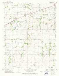
1971 Map of Langdon
USGS Topo · Published 1974About this map
Langdon and Lerado anchor this Reno County landscape, where the agricultural grid meets the industrial infrastructure of the 1970s. The northern half of the map is defined by the Chicago Rock Island and Pacific railroad, which parallels a major pipeline as it passes through the community near Fairfield High Sch and Langdon Cem. Further south, the landscape shifts toward energy production within the Bell and Lerado Oil Field, where numerous oil wells and drill holes are scattered across the terrain near Lerado Cem. A significant historical marker, the Old Indian Treaty Boundary, cuts horizontally across the lower sections of the map, providing a glimpse into the earlier territorial divisions of Kansas. Waterways like Silver Creek, Wolf Creek, and Goose Creek provide natural drainage across the rolling land between the towns.
Find a feature on this map
17 named features on this map. Tap any name to fly to it.
Don’t see what you’re looking for? This feature index may not catch every label — zoom into the map to look around manually.
Map Details
Editions of this 1971 Langdon Map
This is the sole edition of this map. No revisions or reprints were ever made.
Other maps of this area

1892 · Kingman
USGS Topo · 1:125,000

1894 · Kingman
USGS Topo · 1:125,000

1955 · Pratt
USGS Topo · 1:250,000

1959 · Pratt
USGS Topo · 1:250,000

1966 · Cunningham
USGS Topo · 1:24,000

1967 · Kingman NW
USGS Topo · 1:24,000

1967 · Penalosa
USGS Topo · 1:24,000
1971 · Turon
USGS Topo · 1:24,000
1971 · Sylvia
USGS Topo · 1:24,000
1971 · Pretty Prairie SW
USGS Topo · 1:24,000