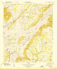
1950 Map of Langston
USGS Topo · Published 1950About this map
The Tennessee River dominates the central landscape of this 1950 survey, where the Guntersville Reservoir Tennessee River winds through the valley between Backbone Ridge and the rising slopes of Sand Mountain. This era shows a community defined by its proximity to the water, with designated recreational zones like the South Sauty Point Cabin Site Area and Lake Shore Drive Cabin Site Area appearing alongside traditional rural settlements. Inland, the town of Langston serves as a local hub, surrounded by numerous family-named landmarks and cemeteries including Langston Cem and Vaught Cem. The terrain is marked by significant gaps such as Langston Gap and Sublett Gap, which historically funneled travel and settlement patterns between the ridges. Educational and religious foundations are evident at sites like the Temperance Hill School and Pleasant Grove Church, illustrating the social fabric of Jackson County during the mid-twentieth century.
Find a feature on this map
54 named features on this map. Tap any name to fly to it.
Don’t see what you’re looking for? This feature index may not catch every label — zoom into the map to look around manually.
Map Details
Editions of this 1950 Langston Map
This is the sole edition of this map. No revisions or reprints were ever made.
Other maps of this area

1885 · Gadsden
USGS Topo · 1:125,000

1886 · Stevenson
USGS Topo · 1:125,000

1888 · Gadsden
USGS Topo · 1:125,000

1888 · Scottsboro
USGS Topo · 1:125,000

1892 · Scottsboro
USGS Topo · 1:125,000

1892 · Stevenson
USGS Topo · 1:125,000

1892 · Gadsden
USGS Topo · 1:125,000

1893 · Fort Payne
USGS Topo · 1:125,000

1895 · Stevenson
USGS Topo · 1:125,000

1895 · Gadsden
USGS Topo · 1:125,000