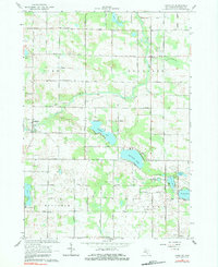
1964 Map of Langston
USGS Topo · Published 1984About this map
Langston and the small settlements of Entrican and Sidney anchor this mid-century look at the central Michigan landscape. The geography is defined by a dense network of glacial lakes and the winding course of the Flat River, which meanders through the townships of Pine, Douglass, and Montcalm. The region's social history is recorded through numerous rural institutions, including the Turk Lake Sch and Turk Lake Ch in the southwest corner, as well as the North Sidney Ch and Entrican Ch. Large water bodies like Clifford Lake and Dickerson Lake are central landmarks, surrounded by gravel pits that suggest the local extraction economy of the era. The grid of country roads, such as Kendaville Road and Stanton Road, connects scattered farms and lakeside residences, providing a clear view of the area's development before modern expansion changed the character of these lakeside communities.
Find a feature on this map
48 named features on this map. Tap any name to fly to it.
Don’t see what you’re looking for? This feature index may not catch every label — zoom into the map to look around manually.
Map Details
Editions of this 1964 Langston Map
2 editions found
Other maps of this area

1954 · Midland
USGS Topo · 1:250,000

1958 · Midland
USGS Topo · 1:250,000

1959 · Midland
USGS Topo · 1:250,000

1959 · Howard City
USGS Topo · 1:62,500

1964 · Edmore
USGS Topo · 1:24,000

1964 · Six Lakes
USGS Topo · 1:24,000

1964 · Langston
USGS Topo · 1:24,000

1964 · Stanton
USGS Topo · 1:24,000

1966 · Midland
USGS Topo · 1:250,000

1972 · Greenville West
USGS Topo · 1:24,000