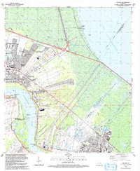
1992 Map of Laplace
USGS Topo · Published 1992About this map
The Bonnet Carre Floodway dominates this Mississippi River landscape, engineered to divert floodwaters between the river and Lake Pontchartrain. Along the riverbanks, historic settlements like Lucy and Gypsy sit opposite the growing industrial corridors of Norco and Laplace. The map documents a complex landscape of heavy industry and natural hazards, notably marking the site of the Hymelia Crevasse (1912) and the extensive Norco Oil and Gas Field.
Find a feature on this map
44 named features on this map. Tap any name to fly to it.
Don’t see what you’re looking for? This feature index may not catch every label — zoom into the map to look around manually.
Map Details
Editions of this 1992 Laplace Map
2 editions found
Other maps of this area

1891 · Hahnville
USGS Topo · 1:62,500

1892 · Lac Des Allemands
USGS Topo · 1:62,500

1892 · Mount Airy
USGS Topo · 1:62,500

1892 · Bonnet Carre
USGS Topo · 1:62,500

1932 · Hahnville NW
USGS Topo · 1:31,680

1932 · Lac Des Allemands NE
USGS Topo · 1:31,680

1932 · Hahnville NE
USGS Topo · 1:31,680

1935 · Laplace
USGS Topo · 1:31,680

1935 · Luling
USGS Topo · 1:31,680

1936 · Hahnville
USGS Topo · 1:31,680