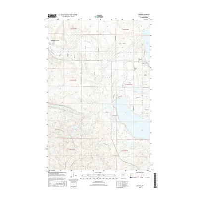
2016 Map of Laporte
USGS Topo · Published 2016About this map
The village of Laporte sits at a geographic crossroads in northern Hubbard County, where the Kabekona River flows through a series of wetland-rich basins. This 2016 survey documents the intricate water network of the region, anchored by the sprawling Kabekona Lake and smaller bodies like Willow Lake and Garfield Lake. Local heritage is preserved in several burial grounds including Saint Theodores Cem, Lakeport Township Cem, and the Evergreen Cem near the intersection at Kabekona Corner. The landscape is a mix of dense forest and aquatic features, with the North Country National Scenic Trail winding through the southwestern section. Modern infrastructure like the Robco Airport and an extensive network of county roads, such as Co HWY 37 and Co HWY 36, serve the rural residential clusters and recreation-focused lakeshores that define the modern character of this woodland community.
Find a feature on this map
60 named features on this map. Tap any name to fly to it.
Don’t see what you’re looking for? This feature index may not catch every label — zoom into the map to look around manually.
Map Details
Editions of this 2016 Laporte Map
This is the sole edition of this map. No revisions or reprints were ever made.
Other maps of this area

1954 · Bemidji
USGS Topo · 1:250,000

1957 · Bemidji
USGS Topo · 1:250,000

1958 · Bemidji
USGS Topo · 1:250,000

1968 · Guthrie
USGS Topo · 1:24,000

1968 · Frontenac Lake
USGS Topo · 1:24,000
1972 · Mantrap Lake
USGS Topo · 1:24,000
1972 · East Crooked Lake
USGS Topo · 1:24,000

1972 · Benedict
USGS Topo · 1:24,000

1972 · Laporte
USGS Topo · 1:24,000

1972 · Lake George
USGS Topo · 1:24,000