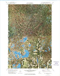
1972 Map of East Crooked Lake
USGS Topo · Published 1974About this map
The Paul Bunyan State Forest dominates this section of Hubbard County, characterized by a complex network of glacial kettle lakes and dense woodland. Surveyed in the early 1970s using high-altitude orthophotography, the map reveals a landscape defined by water and forest management. Significant landmarks like the Thorpe Lookout Tower highlight the importance of fire observation during this era, while scattered Public Access points at Waboose Lake and Spider Lake indicate the growing recreational use of the region's interior. This ortho-topographic study captures the intricate shoreline of East Crooked Lake and the nearby West Crooked Lake, alongside smaller bodies like Coon Lake and Schroeder Lake. The presence of a Gravel Pit and a Roadside Park suggests the localized infrastructure supporting the timber and seasonal transit through these northern woods.
Find a feature on this map
15 named features on this map. Tap any name to fly to it.
Don’t see what you’re looking for? This feature index may not catch every label — zoom into the map to look around manually.
Map Details
Editions of this 1972 East Crooked Lake Map
This is the sole edition of this map. No revisions or reprints were ever made.
Other maps of this area

1953 · Brainerd
USGS Topo · 1:250,000

1954 · Bemidji
USGS Topo · 1:250,000

1957 · Brainerd
USGS Topo · 1:250,000

1957 · Bemidji
USGS Topo · 1:250,000

1958 · Bemidji
USGS Topo · 1:250,000

1958 · Brainerd
USGS Topo · 1:250,000

1965 · Brainerd
USGS Topo · 1:250,000

1970 · Nevis
USGS Topo · 1:24,000

1970 · Dorset
USGS Topo · 1:24,000
1970 · Crystal Lake
USGS Topo · 1:24,000