1972 Map of Laporte
USGS Topo · Published 1986About this map
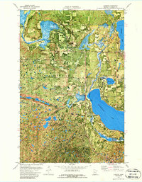
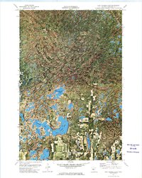
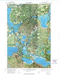
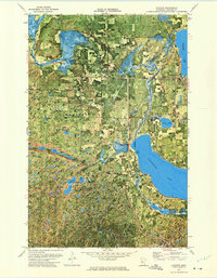
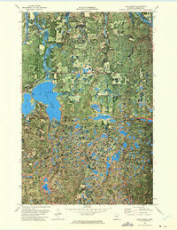
Paul Bunyan State Forest dominates the southern landscape of this orthophotomap, revealing a dense mosaic of woodland and wetlands characteristic of Hubbard County. The settlement of Laporte serves as a local hub near the shores of Garfield Lake, where the Burlington Northern railroad corridor provides a clear industrial line through the lake-strewn terrain. Significant water bodies including Kabekona Lake and the winding Kabekona River illustrate the glacial hydrology of the region, while smaller features like Lake Twentyone and the Bass Lakes are tucked within the protected forest boundaries. Local history is anchored by several rural burying grounds, such as Evergreen Cem and St Theodores Cem, which sit alongside established routes like Kabekona Corner. The map's photographic base captures the literal texture of the forest and fields as they appeared in the early 1970s.
Find a feature on this map
30 named features on this map. Tap any name to fly to it.
Don’t see what you’re looking for? This feature index may not catch every label — zoom into the map to look around manually.
Map Details
Editions of this 1972 Laporte Map
2 editions found
Other maps of this area

1954 · Bemidji
USGS Topo · 1:250,000

1957 · Bemidji
USGS Topo · 1:250,000

1958 · Bemidji
USGS Topo · 1:250,000
1968 · Guthrie
USGS Topo · 1:24,000
1968 · Frontenac Lake
USGS Topo · 1:24,000
1972 · Mantrap Lake
USGS Topo · 1:24,000
1972 · East Crooked Lake
USGS Topo · 1:24,000
1972 · Benedict
USGS Topo · 1:24,000
1972 · Laporte
USGS Topo · 1:24,000
1972 · Lake George
USGS Topo · 1:24,000