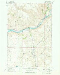
1958 Map of Lapwai
USGS Topo · Published 1973About this map
The confluence of the Clearwater River and Lapwai Creek serves as the geographic and cultural heart of this Idaho landscape. Grounded in Nez Perce history, the map depicts the Nez Perce Nat Historical Park near Spalding and the North Idaho Indian Agency at Lapwai. The terrain transitions from the high Camas Prairie down into the deep canyons of Soldiers Canyon and Beaver Canyon. Infrastructure of the mid-20th century is well-represented, including the Northern Pacific and Camas Prairie railroad lines following the riverbanks. Beyond the settlements of North Lapwai and Sweetwater, the map reveals localized land use ranging from the Lapwai State Game Farm to a small Sand Pit and Quarry, illustrating the intersection of government administration and rural industry in the Lapwai Valley.
Find a feature on this map
36 named features on this map. Tap any name to fly to it.
Don’t see what you’re looking for? This feature index may not catch every label — zoom into the map to look around manually.
Map Details
Editions of this 1958 Lapwai Map
3 editions found
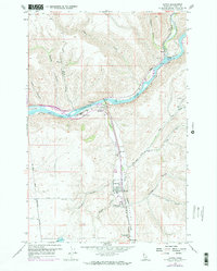
Other maps of this area

1955 · Pullman
USGS Topo · 1:250,000

1958 · Pullman
USGS Topo · 1:250,000

1958 · Lapwai
USGS Topo · 1:24,000

1958 · Sweetwater
USGS Topo · 1:24,000

1958 · Lewiston Orchards North
USGS Topo · 1:24,000

1958 · Lewiston Orchards South
USGS Topo · 1:24,000

1958 · Lewiston Orchards
USGS Topo · 1:62,500

1958 · Culdesac
USGS Topo · 1:62,500

1961 · Kendrick
USGS Topo · 1:62,500

1961 · Moscow
USGS Topo · 1:62,500