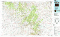
1981 Map of Laramie Peak
USGS Topo · Published 1981About this map
Laramie Peak stands as the central landmark of this 1981 survey, dominating a landscape defined by the intersection of the Medicine Bow National Forest and the sprawling drainages of the Laramie River. The map captures a transition from high-altitude terrain at Baldy Peak and Bear Head Mountain to the eastern plains where the Colorado and Southern railroad runs parallel to Interstate 25. This area reflects the remote settlement patterns of the Wyoming interior, with small hubs like Marshall, Garrett, and Esterbrook serving as vital outposts. Water management is a key feature of the region's development, evidenced by the expansive Glendo Reservoir in the northeast and Wheatland Reservoir No 2 in the south, which capture flow from the North Laramie River and its numerous mountain tributaries.
Find a feature on this map
48 named features on this map. Tap any name to fly to it.
Don’t see what you’re looking for? This feature index may not catch every label — zoom into the map to look around manually.
Map Details
Editions of this 1981 Laramie Peak Map
2 editions found
Other maps of this area

1896 · Hartville
USGS Topo · 1:125,000

1901 · Hartville
USGS Topo · 1:125,000

1915 · Como Ridge
USGS Topo · 1:48,000

1918 · Como Ridge
USGS Topo · 1:62,500

1943 · Esterbrook
USGS Topo · 1:62,500

1945 · Esterbrook
USGS Topo · 1:62,500

1949 · Poison Lake
USGS Topo · 1:24,000

1949 · Cedar Hill
USGS Topo · 1:24,000

1949 · Spring Creek
USGS Topo · 1:24,000

1949 · Dilts Ranch
USGS Topo · 1:24,000