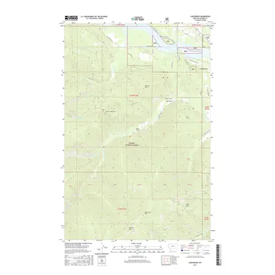
2017 Map of Larchwood
USGS Topo · Published 2017About this map
Noxon Reservoir dominates the northern edge of this 2017 survey, where the Cabinet Mountains transition into the deep drainages of the Kaniksu National Forest. The small settlement of Larchwood sits perched above the reservoir's eastern reach, connected by a network of forest roads like Marten Creek Rd and the Old Hwy. The interior terrain is defined by high ridgelines and steep drainages, including the prominent Beecher Peak, Woodchuck Peak, and Eightmile Peak.
Find a feature on this map
45 named features on this map. Tap any name to fly to it.
Don’t see what you’re looking for? This feature index may not catch every label — zoom into the map to look around manually.
Map Details
Editions of this 2017 Larchwood Map
This is the sole edition of this map. No revisions or reprints were ever made.
Other maps of this area

1932 · Trout Creek
USGS Topo · 1:125,000

1935 · Trout Creek
USGS Topo · 1:125,000

1936 · Trout Creek
USGS Topo · 1:125,000

1956 · Cooper Gulch
USGS Topo · 1:62,500

1956 · Wallace
USGS Topo · 1:250,000

1957 · Burke
USGS Topo · 1:62,500

1960 · Wallace
USGS Topo · 1:250,000
1966 · Goat Peak
USGS Topo · 1:24,000
1966 · Noxon Rapids Dam
USGS Topo · 1:24,000
1966 · Bloom Peak
USGS Topo · 1:24,000