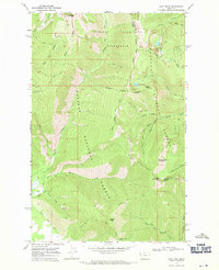
1966 Map of Goat Peak
USGS Topo · Published 1970About this map
The Cabinet Mountains Wilderness dominates this mid-1960s survey, marking a high-elevation landscape where the Kaniksu National Forest and Kootenai National Forest meet. The terrain is defined by prominent summits such as Goat Peak and Silver Butte Mountain, with the Lincoln Co Sanders Co boundary traversing the high ridges. This era of mapping shows a region primarily accessed by an extensive network of pack trails, including the Goat Peak Trail and the Silver Bow Creek Trail, reflecting a period when motorized access was restricted in favor of wilderness preservation.
Find a feature on this map
37 named features on this map. Tap any name to fly to it.
Don’t see what you’re looking for? This feature index may not catch every label — zoom into the map to look around manually.
Map Details
Editions of this 1966 Goat Peak Map
3 editions found
Other maps of this area

1920 · Libby
USGS Topo · 1:125,000

1920 · Jennings
USGS Topo · 1:125,000

1930 · Libby
USGS Topo · 1:125,000

1932 · Libby
USGS Topo · 1:125,000

1932 · Trout Creek
USGS Topo · 1:125,000

1935 · Thompson Lakes
USGS Topo · 1:96,000

1935 · Trout Creek
USGS Topo · 1:125,000

1936 · Trout Creek
USGS Topo · 1:125,000

1937 · Thompson Falls
USGS Topo · 1:125,000

1942 · Thompson Lakes
USGS Topo · 1:125,000