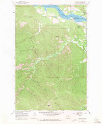
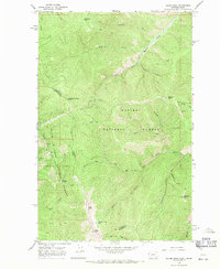
1966 Map of Larchwood
USGS Topo · Published 1971About this map
Noxon Reservoir dominates the northern edge of this 1960s landscape, where the Clark Fork transitions through the Kaniksu National Forest. The settlement of Larchwood sits along the Northern Pacific railroad tracks, serving as a gateway to the high-country drainage basins of Trout Creek. This era of the forest is defined by its accessibility for both industry and recreation, evidenced by the Ambassador Mine located deep in the mountains and the Trout Creek Ranger Sta and Trout Creek Campground near the water. A complex network of pack trails, such as the Minton Creek Trail and West Fork Trout Creek Trail, connects the various gulches to significant topographic heights like Beecher Peak and Minton Creek Pass. The map details the transition from the river valley to the steep ridgelines of White Pine Ridge and peaks including Eightmile Peak.
Find a feature on this map
39 named features on this map. Tap any name to fly to it.
Don’t see what you’re looking for? This feature index may not catch every label — zoom into the map to look around manually.
Map Details
Editions of this 1966 Larchwood Map
2 editions found
Other maps of this area

1932 · Trout Creek
USGS Topo · 1:125,000

1935 · Trout Creek
USGS Topo · 1:125,000

1936 · Trout Creek
USGS Topo · 1:125,000

1956 · Cooper Gulch
USGS Topo · 1:62,500

1956 · Wallace
USGS Topo · 1:250,000

1957 · Burke
USGS Topo · 1:62,500

1960 · Wallace
USGS Topo · 1:250,000
1966 · Goat Peak
USGS Topo · 1:24,000
1966 · Noxon Rapids Dam
USGS Topo · 1:24,000
1966 · Bloom Peak
USGS Topo · 1:24,000