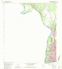
1965 Map of Laredo West
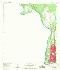
USGS Topo · Published 1980About this map
The Rio Grande marks the international boundary on this mid-century survey, defining the western edge of Laredo where the city meets the border of Tamaulipas. The urban grid is dense with civic and educational history, featuring several schools such as Leyendecker Sch and St Peters Sch, alongside the Holding Institute near the riverbank. Significant infrastructure like the Missouri Pacific railroad and the Toll Port of Entry Bridge US Customs highlights the city's role as a vital transportation and customs hub between the United States and Mexico.
Find a feature on this map
43 named features on this map. Tap any name to fly to it.
Don’t see what you’re looking for? This feature index may not catch every label — zoom into the map to look around manually.
Map Details
Editions of this 1965 Laredo West Map
3 editions found
Historical Maps of Laredo Through Time
355 maps found

1923 Palafox
Webb County, TX

1933 Becerra Creek
Webb County, TX

1937 Aguilete Creek
Webb County, TX

1940 Chupadera
Webb County, TX

1940 San Loranzo Creek
Webb County, TX

1940 Velenzuela Creek
Webb County, TX

1956 Becerra
Webb County, TX

1956 Islitas
Webb County, TX

1956 Laredo East
Webb County, TX

1956 Las Mujeres
Webb County, TX

1956 Las Tiendas
Webb County, TX

1956 Webb
Webb County, TX

1965 Cerritos Blancos
Webb County, TX

1965 Cibolo Ranch
Webb County, TX

1965 Cuervo Creek
Webb County, TX

1965 Dolores Ranch
Webb County, TX

1965 Laredo East
Webb County, TX

1965 Laredo West
Webb County, TX

1965 Las Tiendas
Webb County, TX

1965 Nido Ranch
Webb County, TX

1965 Orvil
Webb County, TX

1965 Spohn Ranch
Webb County, TX

1965 Tios Creek
Webb County, TX

1968 Mills Bennett NW
Webb County, TX

1968 Mills Bennett SW
Webb County, TX

1968 Mills Bennett
Webb County, TX

1968 San Pablo
Webb County, TX

1972 Albercas Ranch
Webb County, TX

1973 Biel Lake North
Webb County, TX

1974 Biel Lake NE
Webb County, TX

1974 Biel Lake SE
Webb County, TX

1974 Biel Lake South
Webb County, TX

1979 Isla Mesteno
Webb County, TX

1979 Laredo South
Webb County, TX

1979 O'Keefe Lake
Webb County, TX

1980 Agua Azul Creek East
Webb County, TX

1980 Agua Azul Creek West
Webb County, TX

1980 Alamito Creek NE
Webb County, TX

1980 Alamito Creek
Webb County, TX

1980 Blancas Creek North
Webb County, TX

1980 Blancas Creek South
Webb County, TX

1980 Burrito Tank
Webb County, TX

1980 Callaghan Ranch North
Webb County, TX

1980 Callaghan Ranch SE
Webb County, TX

1980 Callaghan Ranch South
Webb County, TX

1980 Pato Creek
Webb County, TX

1980 Piedra Parada Ranch
Webb County, TX

1980 Piedra Parada Tank
Webb County, TX

1980 Retama Creek
Webb County, TX

1980 Shipp Ranch
Webb County, TX

1980 Venado Creek East
Webb County, TX

1980 Venado Creek West
Webb County, TX

1982 Dos Hermanos Peaks
Webb County, TX

1982 Galvan Ranch
Webb County, TX

1982 Landrum Tank
Webb County, TX

1982 Mesteno Creek North
Webb County, TX

1982 Mesteno Creek South
Webb County, TX

1982 Piloncillo Hill
Webb County, TX

1982 Pinto Creek
Webb County, TX

1982 Telephone Tanks
Webb County, TX

1982 Velenzuela Creek
Webb County, TX

1983 Big Apache Hill
Webb County, TX

1983 Palafox SW
Webb County, TX

1983 San Pedro Hill
Webb County, TX

1983 South of San Pedro Hill
Webb County, TX

1984 Bull Hollow Tank
Webb County, TX

1984 Chupadera Creek
Webb County, TX

1984 East Losa Tank
Webb County, TX

1984 Tordillo Creek
Webb County, TX

2002 Alamito Creek
Webb County, TX

2010 Agua Azul Creek East
Webb County, TX

2010 Agua Azul Creek West
Webb County, TX

2010 Alamito Creek NE
Webb County, TX

2010 Alamito Creek
Webb County, TX

2010 Albercas Ranch
Webb County, TX

2010 Biel Lake NE
Webb County, TX

2010 Biel Lake North
Webb County, TX

2010 Biel Lake SE
Webb County, TX

2010 Biel Lake South
Webb County, TX

2010 Big Apache Hill
Webb County, TX

2010 Blancas Creek North
Webb County, TX

2010 Blancas Creek South
Webb County, TX

2010 Bull Hollow Tank
Webb County, TX

2010 Burrito Tank
Webb County, TX

2010 Callaghan Ranch North
Webb County, TX

2010 Callaghan Ranch SE
Webb County, TX

2010 Callaghan Ranch South
Webb County, TX

2010 Cerritos Blancos
Webb County, TX

2010 Chupadera Creek
Webb County, TX

2010 Cibolo Ranch
Webb County, TX

2010 Cuervo Creek
Webb County, TX

2010 Dolores Ranch
Webb County, TX

2010 Dos Hermanos Peaks
Webb County, TX

2010 East Losa Tank
Webb County, TX

2010 Galvan Ranch
Webb County, TX

2010 Isla Mesteno
Webb County, TX

2010 Landrum Tank
Webb County, TX

2010 Laredo East
Webb County, TX

2010 Laredo South
Webb County, TX

2010 Laredo West
Webb County, TX

2010 Las Tiendas
Webb County, TX

2010 Mesteno Creek North
Webb County, TX

2010 Mesteno Creek South
Webb County, TX

2010 Mills Bennett NW
Webb County, TX

2010 Mills Bennett SW
Webb County, TX

2010 Mills Bennett
Webb County, TX

2010 Nido Ranch
Webb County, TX

2010 O'Keefe Lake
Webb County, TX

2010 Orvil
Webb County, TX

2010 Palafox SW
Webb County, TX

2010 Pato Creek
Webb County, TX

2010 Piedra Parada Ranch
Webb County, TX

2010 Piedra Parada Tank
Webb County, TX

2010 Piloncillo Hill
Webb County, TX

2010 Pinto Creek
Webb County, TX

2010 Retama Creek
Webb County, TX

2010 San Pablo
Webb County, TX

2010 San Pedro Hill
Webb County, TX

2010 Shipp Ranch
Webb County, TX

2010 South of San Pedro Hill
Webb County, TX

2010 Spohn Ranch
Webb County, TX

2010 Telephone Tanks
Webb County, TX

2010 Tios Creek
Webb County, TX

2010 Tordillo Creek
Webb County, TX

2010 Velenzuela Creek
Webb County, TX

2010 Venado Creek East
Webb County, TX

2010 Venado Creek West
Webb County, TX

2012 Bull Hollow Tank
Webb County, TX

2012 Chupadera Creek
Webb County, TX

2013 Agua Azul Creek East
Webb County, TX

2013 Agua Azul Creek West
Webb County, TX

2013 Alamito Creek NE
Webb County, TX

2013 Alamito Creek
Webb County, TX

2013 Albercas Ranch
Webb County, TX

2013 Biel Lake NE
Webb County, TX

2013 Biel Lake North
Webb County, TX

2013 Biel Lake SE
Webb County, TX

2013 Biel Lake South
Webb County, TX

2013 Big Apache Hill
Webb County, TX

2013 Blancas Creek North
Webb County, TX

2013 Blancas Creek South
Webb County, TX

2013 Burrito Tank
Webb County, TX

2013 Callaghan Ranch North
Webb County, TX

2013 Callaghan Ranch SE
Webb County, TX

2013 Callaghan Ranch South
Webb County, TX

2013 Cerritos Blancos
Webb County, TX

2013 Cibolo Ranch
Webb County, TX

2013 Cuervo Creek
Webb County, TX

2013 Dolores Ranch
Webb County, TX

2013 Dos Hermanos Peaks
Webb County, TX

2013 East Losa Tank
Webb County, TX

2013 Galvan Ranch
Webb County, TX

2013 Isla Mesteno
Webb County, TX

2013 Landrum Tank
Webb County, TX

2013 Laredo East
Webb County, TX

2013 Laredo South
Webb County, TX

2013 Laredo West
Webb County, TX

2013 Las Tiendas
Webb County, TX

2013 Mesteno Creek North
Webb County, TX

2013 Mesteno Creek South
Webb County, TX

2013 Mills Bennett NW
Webb County, TX

2013 Mills Bennett SW
Webb County, TX

2013 Mills Bennett
Webb County, TX

2013 Nido Ranch
Webb County, TX

2013 O'Keefe Lake
Webb County, TX

2013 Orvil
Webb County, TX

2013 Palafox SW
Webb County, TX

2013 Pato Creek
Webb County, TX

2013 Piedra Parada Ranch
Webb County, TX

2013 Piedra Parada Tank
Webb County, TX

2013 Piloncillo Hill
Webb County, TX

2013 Pinto Creek
Webb County, TX

2013 Retama Creek
Webb County, TX

2013 San Pablo
Webb County, TX

2013 San Pedro Hill
Webb County, TX

2013 Shipp Ranch
Webb County, TX

2013 South of San Pedro Hill
Webb County, TX

2013 Spohn Ranch
Webb County, TX

2013 Telephone Tanks
Webb County, TX

2013 Tios Creek
Webb County, TX

2013 Tordillo Creek
Webb County, TX

2013 Velenzuela Creek
Webb County, TX

2013 Venado Creek East
Webb County, TX

2013 Venado Creek West
Webb County, TX

2016 Agua Azul Creek East
Webb County, TX

2016 Agua Azul Creek West
Webb County, TX

2016 Alamito Creek NE
Webb County, TX

2016 Alamito Creek
Webb County, TX

2016 Albercas Ranch
Webb County, TX

2016 Biel Lake NE
Webb County, TX

2016 Biel Lake North
Webb County, TX

2016 Biel Lake SE
Webb County, TX

2016 Biel Lake South
Webb County, TX

2016 Big Apache Hill
Webb County, TX

2016 Blancas Creek North
Webb County, TX

2016 Blancas Creek South
Webb County, TX

2016 Bull Hollow Tank
Webb County, TX

2016 Burrito Tank
Webb County, TX

2016 Callaghan Ranch North
Webb County, TX

2016 Callaghan Ranch SE
Webb County, TX

2016 Callaghan Ranch South
Webb County, TX

2016 Cerritos Blancos
Webb County, TX

2016 Chupadera Creek
Webb County, TX

2016 Cibolo Ranch
Webb County, TX

2016 Cuervo Creek
Webb County, TX

2016 Dolores Ranch
Webb County, TX

2016 Dos Hermanos Peaks
Webb County, TX

2016 East Losa Tank
Webb County, TX

2016 Galvan Ranch
Webb County, TX

2016 Isla Mesteno
Webb County, TX

2016 Landrum Tank
Webb County, TX

2016 Laredo East
Webb County, TX

2016 Laredo South
Webb County, TX

2016 Laredo West
Webb County, TX

2016 Las Tiendas
Webb County, TX

2016 Mesteno Creek North
Webb County, TX

2016 Mesteno Creek South
Webb County, TX

2016 Mills Bennett NW
Webb County, TX

2016 Mills Bennett SW
Webb County, TX

2016 Mills Bennett
Webb County, TX

2016 Nido Ranch
Webb County, TX

2016 O'Keefe Lake
Webb County, TX

2016 Orvil
Webb County, TX

2016 Palafox SW
Webb County, TX

2016 Pato Creek
Webb County, TX

2016 Piedra Parada Ranch
Webb County, TX

2016 Piedra Parada Tank
Webb County, TX

2016 Piloncillo Hill
Webb County, TX

2016 Pinto Creek
Webb County, TX

2016 Retama Creek
Webb County, TX

2016 San Pablo
Webb County, TX

2016 San Pedro Hill
Webb County, TX

2016 Shipp Ranch
Webb County, TX

2016 South of San Pedro Hill
Webb County, TX

2016 Spohn Ranch
Webb County, TX

2016 Telephone Tanks
Webb County, TX

2016 Tios Creek
Webb County, TX

2016 Tordillo Creek
Webb County, TX

2016 Velenzuela Creek
Webb County, TX

2016 Venado Creek East
Webb County, TX

2016 Venado Creek West
Webb County, TX

2019 Agua Azul Creek East
Webb County, TX

2019 Agua Azul Creek West
Webb County, TX

2019 Alamito Creek NE
Webb County, TX

2019 Alamito Creek
Webb County, TX

2019 Albercas Ranch
Webb County, TX

2019 Biel Lake NE
Webb County, TX

2019 Biel Lake North
Webb County, TX

2019 Biel Lake SE
Webb County, TX

2019 Biel Lake South
Webb County, TX

2019 Big Apache Hill
Webb County, TX

2019 Blancas Creek North
Webb County, TX

2019 Blancas Creek South
Webb County, TX

2019 Bull Hollow Tank
Webb County, TX

2019 Burrito Tank
Webb County, TX

2019 Callaghan Ranch North
Webb County, TX

2019 Callaghan Ranch SE
Webb County, TX

2019 Callaghan Ranch South
Webb County, TX

2019 Cerritos Blancos
Webb County, TX

2019 Chupadera Creek
Webb County, TX

2019 Cibolo Ranch
Webb County, TX

2019 Cuervo Creek
Webb County, TX

2019 Dolores Ranch
Webb County, TX

2019 Dos Hermanos Peaks
Webb County, TX

2019 East Losa Tank
Webb County, TX

2019 Galvan Ranch
Webb County, TX

2019 Isla Mesteno
Webb County, TX

2019 Landrum Tank
Webb County, TX

2019 Laredo East
Webb County, TX

2019 Laredo South
Webb County, TX

2019 Laredo West
Webb County, TX

2019 Las Tiendas
Webb County, TX

2019 Mesteno Creek North
Webb County, TX

2019 Mesteno Creek South
Webb County, TX

2019 Mills Bennett NW
Webb County, TX

2019 Mills Bennett SW
Webb County, TX

2019 Mills Bennett
Webb County, TX

2019 Nido Ranch
Webb County, TX

2019 O'Keefe Lake
Webb County, TX

2019 Orvil
Webb County, TX

2019 Palafox SW
Webb County, TX

2019 Pato Creek
Webb County, TX

2019 Piedra Parada Ranch
Webb County, TX

2019 Piedra Parada Tank
Webb County, TX

2019 Piloncillo Hill
Webb County, TX

2019 Pinto Creek
Webb County, TX

2019 Retama Creek
Webb County, TX

2019 San Pablo
Webb County, TX

2019 San Pedro Hill
Webb County, TX

2019 Shipp Ranch
Webb County, TX

2019 South of San Pedro Hill
Webb County, TX

2019 Spohn Ranch
Webb County, TX

2019 Telephone Tanks
Webb County, TX

2019 Tios Creek
Webb County, TX

2019 Tordillo Creek
Webb County, TX

2019 Velenzuela Creek
Webb County, TX

2019 Venado Creek East
Webb County, TX

2019 Venado Creek West
Webb County, TX

2022 Agua Azul Creek East
Webb County, TX

2022 Agua Azul Creek West
Webb County, TX

2022 Alamito Creek NE
Webb County, TX

2022 Alamito Creek
Webb County, TX

2022 Albercas Ranch
Webb County, TX

2022 Biel Lake NE
Webb County, TX

2022 Biel Lake North
Webb County, TX

2022 Biel Lake SE
Webb County, TX

2022 Biel Lake South
Webb County, TX

2022 Big Apache Hill
Webb County, TX

2022 Blancas Creek North
Webb County, TX

2022 Blancas Creek South
Webb County, TX

2022 Bull Hollow Tank
Webb County, TX

2022 Burrito Tank
Webb County, TX

2022 Callaghan Ranch North
Webb County, TX

2022 Callaghan Ranch SE
Webb County, TX

2022 Callaghan Ranch South
Webb County, TX

2022 Cerritos Blancos
Webb County, TX

2022 Chupadera Creek
Webb County, TX

2022 Cibolo Ranch
Webb County, TX

2022 Cuervo Creek
Webb County, TX

2022 Dolores Ranch
Webb County, TX

2022 Dos Hermanos Peaks
Webb County, TX

2022 East Losa Tank
Webb County, TX

2022 Galvan Ranch
Webb County, TX

2022 Isla Mesteno
Webb County, TX

2022 Landrum Tank
Webb County, TX

2022 Laredo East
Webb County, TX

2022 Laredo South
Webb County, TX

2022 Laredo West
Webb County, TX

2022 Las Tiendas
Webb County, TX

2022 Mesteno Creek North
Webb County, TX

2022 Mesteno Creek South
Webb County, TX

2022 Mills Bennett NW
Webb County, TX

2022 Mills Bennett SW
Webb County, TX

2022 Mills Bennett
Webb County, TX

2022 Nido Ranch
Webb County, TX

2022 O'Keefe Lake
Webb County, TX

2022 Orvil
Webb County, TX

2022 Palafox SW
Webb County, TX

2022 Pato Creek
Webb County, TX

2022 Piedra Parada Ranch
Webb County, TX

2022 Piedra Parada Tank
Webb County, TX

2022 Piloncillo Hill
Webb County, TX

2022 Pinto Creek
Webb County, TX

2022 Retama Creek
Webb County, TX

2022 San Pablo
Webb County, TX

2022 San Pedro Hill
Webb County, TX

2022 Shipp Ranch
Webb County, TX

2022 South of San Pedro Hill
Webb County, TX

2022 Spohn Ranch
Webb County, TX

2022 Telephone Tanks
Webb County, TX

2022 Tios Creek
Webb County, TX

2022 Tordillo Creek
Webb County, TX

2022 Velenzuela Creek
Webb County, TX

2022 Venado Creek East
Webb County, TX

2022 Venado Creek West
Webb County, TX