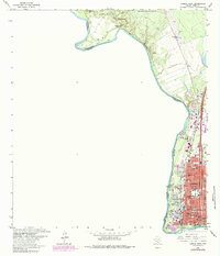
1965 Map of Laredo West
USGS Topo · Published 1984About this map
The Rio Grande marks the international divide in this 1960s study of Laredo, where the city's street grid presses against the river's edge. The industrial and transportation infrastructure of the border is evident, from the Missouri Pacific and Texas Mexican railroads to the Port of Entry Bridge and U S Customs station. The presence of Port McIntosh and various Ruins suggests a deep history of military and civic evolution on the Texas-Tamaulipas border.
Find a feature on this map
63 named features on this map. Tap any name to fly to it.
Don’t see what you’re looking for? This feature index may not catch every label — zoom into the map to look around manually.
Map Details
Editions of this 1965 Laredo West Map
3 editions found
Other maps of this area

1933 · Becerra Creek
USGS Topo · 1:62,500

1956 · Islitas
USGS Topo · 1:62,500

1956 · Laredo East
USGS Topo · 1:62,500

1956 · Laredo
USGS Topo · 1:250,000

1965 · Laredo West
USGS Topo · 1:24,000

1965 · Orvil
USGS Topo · 1:24,000

1965 · Cuervo Creek
USGS Topo · 1:24,000
1965 · Dolores Ranch
USGS Topo · 1:24,000

1965 · Laredo East
USGS Topo · 1:24,000

1979 · Laredo South
USGS Topo · 1:24,000