
1963 Map of Lariat
USGS Topo · Published 1965About this map
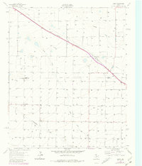
The Panhandle and Santa Fe railroad cuts a diagonal line across this High Plains landscape, anchoring the small community of Lariat. This 1963 survey captures a rural landscape defined by an extensive grid of agricultural wells and the seasonal paths of Lariat Draw and Blackwater Draw. The presence of both the Lariat Cem and West Camp Cem provides specific points of interest for genealogists tracing families in the area.
Find a feature on this map
11 named features on this map. Tap any name to fly to it.
Don’t see what you’re looking for? This feature index may not catch every label — zoom into the map to look around manually.
Map Details
Editions of this 1963 Lariat Map
2 editions found
Other maps of this area

1954 · Clovis
USGS Topo · 1:250,000

1957 · Clovis
USGS Topo · 1:62,500

1957 · Arch
USGS Topo · 1:62,500

1958 · Clovis
USGS Topo · 1:250,000

1962 · Birdwell Ranch
USGS Topo · 1:24,000

1962 · Baileyboro NE
USGS Topo · 1:24,000

1963 · Oklahoma Lane
USGS Topo · 1:24,000

1963 · Lariat NE
USGS Topo · 1:24,000

1963 · Progress
USGS Topo · 1:24,000

1985 · Pleasure Lake
USGS Topo · 1:24,000