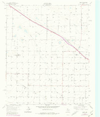
1963 Map of Lariat
USGS Topo · Published 1981About this map
The Panhandle and Santa Fe railroad cuts a diagonal path across this High Plains landscape, anchoring the small settlement of Lariat. This survey, updated with aerial data through the late 1970s, illustrates the deep reliance on groundwater in the Texas Panhandle, with hundreds of irrigation wells peppering the terrain near the Parmer Co Bailey Co line. These wells support the agricultural economy that defines the area around West Camp and the small siding at Parley.
Find a feature on this map
14 named features on this map. Tap any name to fly to it.
Don’t see what you’re looking for? This feature index may not catch every label — zoom into the map to look around manually.
Map Details
Editions of this 1963 Lariat Map
2 editions found
Other maps of this area

1954 · Clovis
USGS Topo · 1:250,000

1957 · Clovis
USGS Topo · 1:62,500

1957 · Arch
USGS Topo · 1:62,500

1958 · Clovis
USGS Topo · 1:250,000

1962 · Birdwell Ranch
USGS Topo · 1:24,000

1962 · Baileyboro NE
USGS Topo · 1:24,000

1963 · Lariat
USGS Topo · 1:24,000

1963 · Oklahoma Lane
USGS Topo · 1:24,000

1963 · Lariat NE
USGS Topo · 1:24,000

1963 · Progress
USGS Topo · 1:24,000