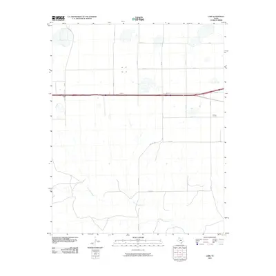
2010 Map of Lark
USGS Topo · Published 2010About this map
The settlement of Lark anchors this portion of the Texas Panhandle, positioned along a major east-west transportation corridor. The landscape is defined by the headwaters of the Salt Fork Red River, which carves a drainage pattern through the southern half of the quadrangle. North of the river, the terrain is characterized by numerous small, seasonal basins and a grid-like network of county roads including Co Rd X and Co Rd Y. The presence of the Groom Cemetery in the eastern section provides a specific point of interest for genealogists tracing local families. This 2010 survey reflects a rural environment where ranching and local travel are supported by routes like FM 294 and Ranch Rd 294, while the interstate system facilitates movement across the High Plains.
Find a feature on this map
21 named features on this map. Tap any name to fly to it.
Don’t see what you’re looking for? This feature index may not catch every label — zoom into the map to look around manually.
Map Details
Editions of this 2010 Lark Map
This is the sole edition of this map. No revisions or reprints were ever made.
Other maps of this area

1954 · Amarillo
USGS Topo · 1:250,000

1958 · Amarillo
USGS Topo · 1:250,000

1960 · Claude
USGS Topo · 1:62,500

1960 · Groom
USGS Topo · 1:62,500

1966 · Grandview School
USGS Topo · 1:24,000

1966 · Panhandle East
USGS Topo · 1:24,000

1966 · White Deer SW
USGS Topo · 1:24,000
1983 · Ashtola
USGS Topo · 1:24,000
1983 · Lark
USGS Topo · 1:24,000
1983 · Claude
USGS Topo · 1:24,000